


Agricultural News
Freezing Temps Cover Almost the Northwestern Half of Oklahoma- Again
Wed, 24 Apr 2013 06:05:45 CDT
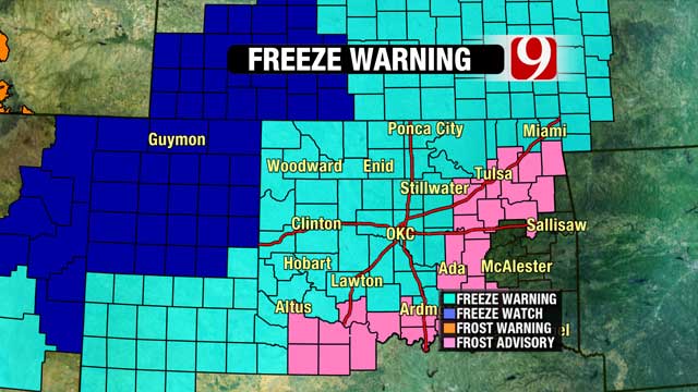
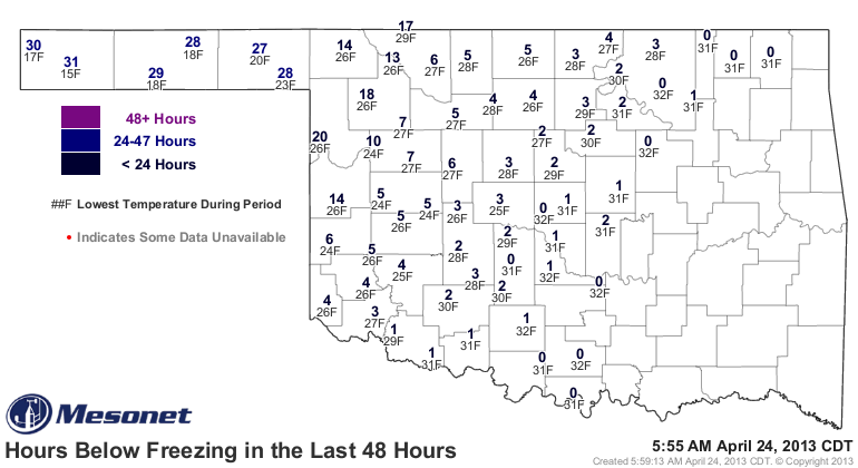 Oklahoma's 2013 winter canola and winter wheat crops are facing one more night of freezing temperatures- with some of the temperatures likely to set records here for the latter part of April. The temperature map we are showing you above shows the number of hours of freezing temperatures we have had at any one location for the past 48 hours. You will be able to add a couple more hours to most of those totals before things warm up later on this Wednesday morning. The map shown below is the prediction of where freezing conditions were expected this morning across Oklahoma, Kansas and north Texas.
There is a tremendous fear of the additional damage this widespread outbreak of artic air may cause for both the wheat and canola crops- already stressed by drought and several earlier frigid mornings since mid March. The 2013 crops are far less developed than we saw in the 2012 season- and after harvesting a great deal of our wheat and canola in May last season- we will return to a June harvest schedule for this year- at least for those fields which survive these latest sub freezing temps. Wheat that has survived previous freeze mornings will not show any signs of damage for about seven days- and Canola also will need a few days to show how badly it has been burned back by the freeze-
News on 6 weatherman Alan Crone offers some play by play of the weather system impacting us now- and what's next- here is a portion of his Wednesday morning blog post:
"After a very cold morning, we will see sunshine and highs in the upper 50s to near 60 with light northwest winds. The next system arrives Friday with a chance of showers and storms. Warmer air will arrive this weekend.
"Wow! How about this cold air mass across the region? Record cold temps are underway across a large portion of the central plains, including most of northern OK. High temperatures yesterday were reached during the early morning hours before the arctic front surged southward across the state. The only area that did not see a massive temperature change was extreme southeastern OK and northeast TX. Almost the entire state dropped into the upper 30s and lower 40s. Very unusual for Mid-to late April.
"Overnight a small area of snow flurries or drizzle made an appearance across extreme northern OK and southeastern Kansas, but the main issue is clearing sky and decreasing wind. Consequently, our friends from the NWS in Tulsa (and other offices) have issued a frost advisory and a freeze warning for a large chunk of our area through the early morning hours.
"After the morning hours, we'll see a surface ridge of high pressure begin to build across NE OK allowing for northwest surface winds around 5 to 7 mph and temperatures moving into the upper 50s or lower 60s. While these readings will continue to be below the normal high for Mid-April, this will signal the demise of the shallow Arctic air mass. The colder air will slide east while south winds return Thursday. Thursday afternoon highs are expected to move into the upper 60s or lower 70s with mostly sunny conditions."
Click here to read the rest of his posting for this Wednesday morning.
WebReadyTM Powered by WireReady® NSI
Top Agricultural News
More Headlines...


