


Agricultural News
Cold Temperatures Wednesday Morning Smashed Previous Low Temp Records
Thu, 25 Apr 2013 04:55:12 CDT
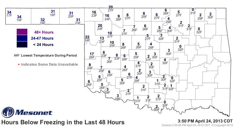 Bitterly cold readings turned out to be widespread across Oklahoma early Wednesday morning- and the lowest reading in the state- 15 degrees in Boise City- ended up setting several records. The map above shows the lowest readings Wednesday morning- and how many hours each Mesonet station was below freezing through yesterday in the last two days. The number of hours is such that wheat that had not received damage to this point of this up and down growing season likely was hurt badly in what hopefully will be the final freeze of the spring 2013 season.
Back to the low temperature readings of Wednesday morning, Gary McManus of the Oklahoma Climatological Survey explains the record breaking aspect of the event- "the lowest temperature ever recorded for this date in history was 21 degrees from Idabel in 1910, although I think that datum is a bit suspect. We'll have to investigate that one. Next on the list would be 24 degrees from Guthrie back in 1893 and 25 degrees from Beaver back in 1968. At any rate, regardless of the validity of Idabel's reading of 21 degrees, that record was shattered.
"Hold on, still going! Not only was it the coldest temperature ever recorded on April 24 back into history, it's the LATEST coldest temperature ever recorded in history. So the previous latest day a temperature of 15 degrees was recorded was April 14. That occurred at Goodwell and Turpin back in 1997. So the 15 degrees at Boise City this morning was the latest to see that cold of a reading by 10 days or so."
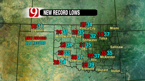
Daily record lows fell all over the place- the News9 weather team provides a graph of those new record lows from Wednesday morning in the map that is below.
Meanwhile, Alan Crone of the News on 6 offers us the latest ideas about the next storm system that is now approaching the region and should provide more rain on Friday. "The main upper level system is located off the Baja this morning but will move eastward quickly today and should begin to open and weaken. This will cause the surface pressure to fall across the western portion of the panhandle developing a surface area of low pressure somewhere from near Lubbock to the NW OK area. This low will drop southeast by Friday night into Saturday morning. South winds will draw moisture northward across the state tomorrow with showers and storms developing at times over the state. The lack of quality and deep low level moisture should greatly limit the severe weather to areas along the Red River Valley of OK into portions of north TX."
Alan also blogs this morning about next week- "Next week continues to offer some controversy. The consensus calls for a few showers or storms Tuesday, but a surface cold front will arrive either Tuesday night into Wednesday, or Wednesday night into Thursday morning. It's impossible at this moment to offer any confidence on the timing of the midweek system. The depth of moisture in the atmosphere combined with the expected wind profiles would support the threat of severe weather."
Click here to read all of Alan's Thursday morning weather thoughts from the News on 6 website.
WebReadyTM Powered by WireReady® NSI
Top Agricultural News
More Headlines...


