


Agricultural News
Updated- Drought Monitor Shows Shrinking Drought Footprint in Oklahoma
Fri, 26 Apr 2013 05:56:05 CDT
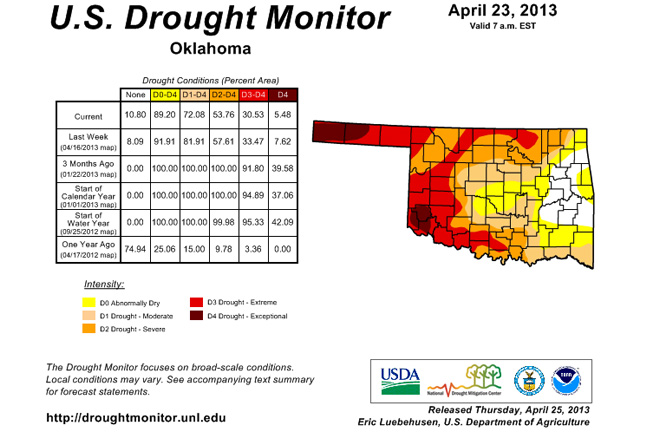
Rainfall along the I-44 corridor brought more drought relief to the state last week. The improvements from east central through central Oklahoma leave 28 percent of the state without any sort of drought designation (11 percent with no designation, 17 percent with the "Abnormally Dry, D0" designation). The latest Drought Monitor graphic can be seen above.
That still leaves 72 percent of the state within some level of drought intensity. Only 5 percent or so is in the "Exceptional, D4" category, the best that column has looked since July 31, 2012. Nearly 31 percent of the state is within the "Extreme/Exceptional" categories ... a level that has not been that low since July 17, 2012.
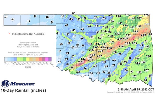
While some areas are dealing with overflowing lakes and ponds, the Panhandle is still dealing with very dry conditions. The rainfall amounts over the last week and a half can be seen in our graphic at the bottom of this story.
There are chances for rain today as well as the middle of next week. The latest 7-day rain total forecast shows the same old story and more for the east and paltry amounts for the west.
According to the Friday morning weather blog written by Alan Crone from the News on 6- the storm system for next week could give us a wild ride. "The weather pattern will become very active by the middle of the week and it may get very interesting.
"The GFS and EURO continue to offer big differences in the pattern, but both do suggest a strong font approaching the area during the Wednesday and Thursday time periods. The GFS is somewhat faster and would bring the front across the area Wednesday with a robust chance of storms and a modest cool down. The EURO is a day later, and would bring a cool down for Thursday into Friday. The EURO yesterday morning had been flirting with developing a closed low across the central plains and brought this feature directly over the state late next week. The very latest run does not feature the closed system for our area. Stay tuned. It could get wacky again next week!"
WebReadyTM Powered by WireReady® NSI
Top Agricultural News
More Headlines...


