


Agricultural News
Red Rock Tops Five Inches of Rainfall Over Past 2 Days- And Some Severe Weather Ahead- The Latest Weather Graphics to Review
Thu, 30 May 2013 04:14:46 CDT
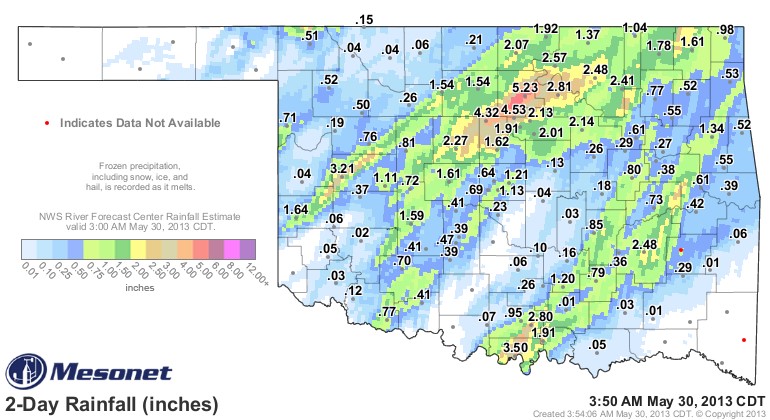 Rainfall totals across Oklahoma have been highest thus far this week in two bands- one that stretches from Erick to Fort Cobb and then north and east in a broad stroke all the way into southeastern Kansas. Over the past 48 nhours- the heaviest rainfall total at a Mesonet station has been seen at Red Rock- with 5.23 inches of rainfall. A host of other locations have had two and three inch rainfall totals. The latest rainfall total map is seen above, courtesy of the Mesonet.
The second band of rain that has been seen this week streches from Burneyville to Tahlequah- with Burneyville's Mesonet station seeing a total of 3.5 inches of rain over the 48 hour period that ended early Thursday morning.
Rainfall continues to pile up totals in northeastern Oklahoma- so totals in Green Country will continue to grow.
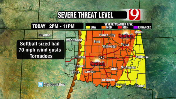
And according to Jed Castles with News9 in Oklahoma City, Thursday could be another rainy and stormy day across Oklahoma. His latest graphic is seen below- with the middle half of the state or a little more could face severe weather after 2 PM on Thursday.
WebReadyTM Powered by WireReady® NSI
Top Agricultural News
More Headlines...


