


Agricultural News
Latest Drought Monitor Shows More Drought West, Less Drought East
Thu, 30 May 2013 21:21:50 CDT
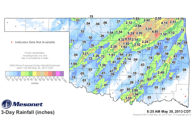
Severe weather yesterday and Wednesday brought prodigious amounts of rain to central and eastern Oklahoma as evidenced by the map above. Western Oklahoma has remained relatively dry says Associate State Climatologist Gary McManus.
The Mesonet rainfall maps show Red Rock in Noble County had more than 5 inches of rainfall from training thunderstorms Wednesday. More heavy rains fell yesterday.
In fact, that area from Kingfisher County through Nowata County got blasted by widespread 3-5 inch amounts. There was also obviously a pretty potent storm that traveled from Beckham County through Kay County, dumping 1-2 inches in general, with 3.21 inches measured at the Butler Mesonet site. And there was another area of storms that went from Love County in the south to Cherokee County in the northeast, dropping 1-3 inches along the way, with localized heavier amounts.
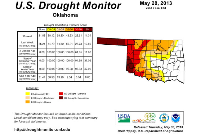
The most recent U.S. Drought Monitor map, below, will likely show many changes next week due to the rainfall, but the dry areas in the western part of the start are accurate, McManus says. Areas of D4 spread just a little bit across far
western Oklahoma and have now crept up to cover 11.34% of the state. At the same time, the amount of D0-D4 has gone down from 75% to 68%. What that says is that drought is intensifying in the west and going away in the east.
What that means is that central through eastern Oklahoma is winning the race to the summer heat, while the western (along with southern and northern Oklahoma) area is losing the race. The western third of the state is showing annual rainfall running less than 40 percent of normal, about the same as it did during the last two years of drought.
WebReadyTM Powered by WireReady® NSI
Top Agricultural News
More Headlines...


