


Agricultural News
Border to Border Rains Fall Across Oklahoma as Week Begins- Here are the Latest Maps
Mon, 17 Jun 2013 05:58:52 CDT
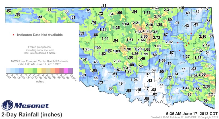 Rainfall totals have piled up across a wide section of the state- and the map that extends back to early Saturday morning shows rainfall even in the far end of the Oklahoma Panhandle at both the Boise City and Kenton Mesonet stations- both showing almost an inch of rain in the gauge. The rainfall map above shows the two day totals.
High rainfall total through 5:30 AM Monday morning is Lake Carl Blackwell at 4.3 inches of rain- while Broken Bow has had 3.25 inches of rain since Saturday morning and likely more to come from this current system as it works its way south and east.
As Monday unfolds- it is likely to be hot and muggy in western areas of the state- while the eastern counties are not likely to be as hot today. Alan Crone with the News on 6 in Tulsa offers this outlook for Monday evening- "The upper air flow remains from the northwest and may allow another MCS ( complex) to develop later tonight across southwestern Kansas and move into western OK. Most of the model data support this system remaining west of Tulsa and northeastern Oklahoma, but with northwest flow aloft, one must remain aware of the potential. We'll keep a chance in our forecast for some late tonight and early morning storms for Tuesday morning before taking the probability southward across the southern sections of the state Tuesday afternoon and evening.
"Wednesday morning will also support a slight chance of another MCS nearby, but the confidence remains low, therefore the probability will remain low for our forecast cycle this morning.
"The mid-level ridge of high pressure will build back into the region by the end of the week allowing for muggy and warm conditions with highs in the lower to mid-90s and morning lows in the lower to mid-70s."
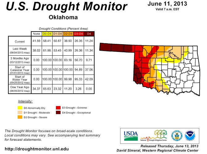
And- as we start the week- a quick look back to last Thursday's latest drought monitor- which showed last week that we have reached the fifty fifty mark in Oklahoma- half of the state remains in drought in last week's report with the other half showing about eight or nine percent in abnormally dry conditions and over 41% of the state now out of drought or abnormally dry conditions altogether.
With these most recent rains- that "out of drought" number is very very likely to jump higher this coming Thursday when we get our next Drought Monitor update. The latest Drought Monitor map is below.
WebReadyTM Powered by WireReady® NSI
Top Agricultural News
More Headlines...


