


Agricultural News
Drought Improves Markedly Across Much of Oklahoma
Thu, 20 Jun 2013 16:58:59 CDT
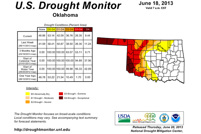
Associate State Climatologist Gary McManus says the latest drought map shows improvement across Oklahoma, but it may be the last to show that for a while. An upper-level ridge of high pressure appears ready to park itself over the Southern Plains, decreasing chances for rain over the next week to ten days.
The first three weeks of June provided much needed rain across the state even in the Panhandle. McManus said the rains that have fallen since February brought 29.7 inches to Mt. Herman and 3.1 inches to Boise City. Two-point-one inches of Boise City's total fell in the last 30 days. It won't last long, however, as triple digit temperatures are expected along with the high-pressure system.
The latest U.S. drought map shows significant improvement across much of Oklahoma with many areas dropping from D4 to D3.
McManus said the relief will be short-lived as hotter temperatures and high winds set up over the Panhandle. Winds of 35-40 mph can be expected in the short term and, unfortunately, some areas in Cimarron County have started to blow.
The long-term outlook for July through September shows above-average temperatures and below-average rainfall especially in the west, McManus said, but for the time being we can bask in the knowledge that much of the state has improved dramatically in drought conditions.
WebReadyTM Powered by WireReady® NSI
Top Agricultural News
More Headlines...


