


Agricultural News
Bitter Cold Headed for the Middle US- Including Oklahoma- The Latest Maps
Tue, 03 Dec 2013 05:50:11 CST
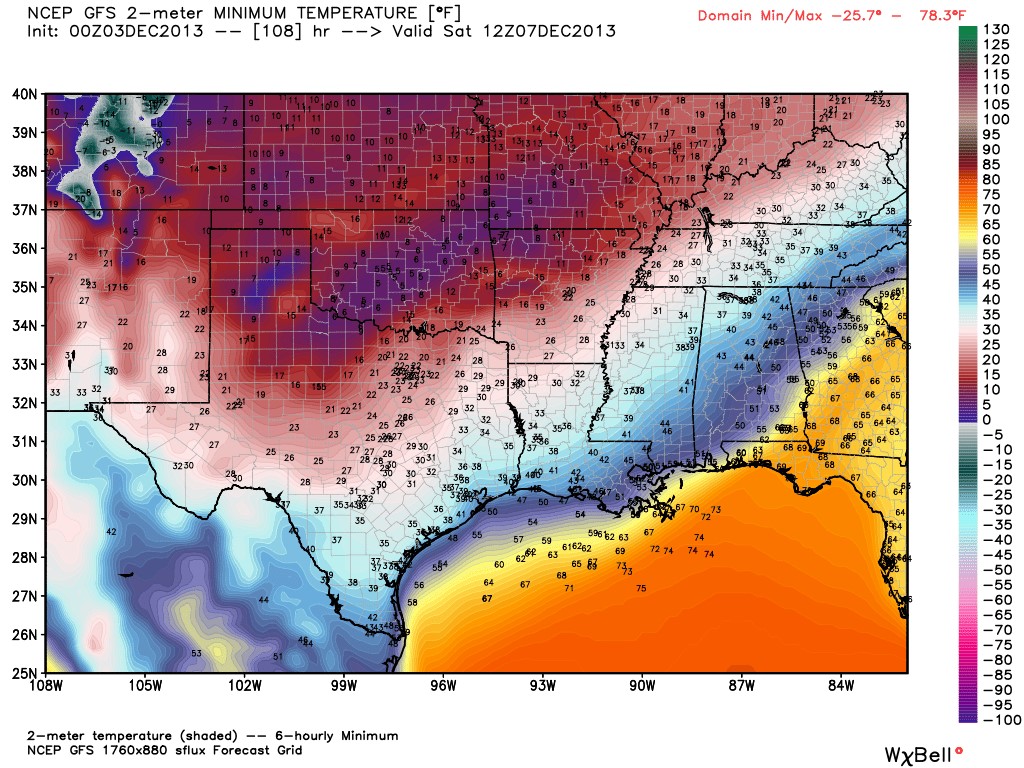
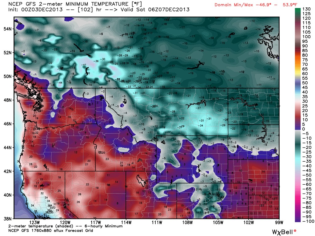 Bitterly cold temperatures have broken out of the arctic and are already moving towards Oklahoma. The map above reflects what temps could look like by Saturday morning in the northern part of the US. The picture below is of the southern great plains- including Oklahoma and Texas- where temperatures will not approach zero- but will be down into the single digits if this model holds true.
News on 6 meterologist Alan Crone has an excellent review of the colder air and the wintery mix of preciptitation that will be with us Thursday all the way to probably Monday before we will see temperatures above 32 degrees once we go into freezing territory on Wednesday night.
From his daily blog on the News on 6 website- here is what Alan says about the weather ahead:
"The initial wind shift/cold front will arrive pre-dawn Wednesday with north winds and cooler air. Temps may rebound in the lower 50s by midday and drop into the lower 40s by Wednesday late afternoon with increasing clouds and a few sprinkles across eastern OK and western Arkansas. The chance for any measurable precip tomorrow remains near or less than 10% for our eastern OK.
"Frigid air will spill into the state Wednesday night and Thursday morning setting the stage for a prolonged period of sub-freezing temperatures that may last for 96 to 120 hours. We may not move above freezing until late Monday afternoon.
"The upper air flow from the southwest will bring a disturbance over the central and southern OK area by Thursday morning to midday resulting in precipitation developing across part of the state. The shallow nature of the arctic air may allow for freezing rain and rain across far southern OK, a mixture of freezing rain and sleet across the I-44 corridor, and all snow northwest of the I-44 area for the initial on-set of the precipitation. The latest data support the higher chances for precip will occur along the I-44 corridor and locations southeast. The temperature profile by midday will support slightly deeper cold air across the I-44 corridor which would allow for a transition from sleet to some snow by afternoon while southeastern sections may see a transition from freezing rain to sleet. Friday morning another slug of moisture may move up and over the central and eastern OK area but the temp profile would be deep and cold enough for mainly snow across the northern third of the state and a mixture of sleet and snow to the southeast up through the Arkansas valley of east-central OK. Model data also supports a small departing upper level wave Saturday night into Sunday morning across the eastern third of the state with the temp profile in the atmosphere supporting all snow.
"The exact amount of accumulating precipitation is problematic due to the varying transitions of precip types during the early stages of the event. A general idea of 2 to 4 inches of wintry precip seems a possibility along the I-44 corridor through Sunday morning. Some icing in the form of .10 to .18 of an inch unfortunately is a possibility across the southeastern third of the area, generally south of the I-40 corridor and east of I-35.
"Residents across central and eastern OK should remain aware of the cold air and winter weather potential. Refinements to the precip type and accumulation amounts will continue to be made as confidence increases in the outcome of the system. Regardless of the exact amounts, the confidence for travel impacts due to wintry precipitation continues to increase. If the ice-freezing rain portion of the forecast verifies, some power outages may be a possibility across a narrow area of southeastern or east-central OK."
To read his full comments- including details for today- click here.
WebReadyTM Powered by WireReady® NSI
Top Agricultural News
More Headlines...


