Agricultural News
Wind Chill in Single Digits and Lower in Oklahoma- Not as Brutal as Northern Plains- The Latest Map
Mon, 06 Jan 2014 05:47:44 CST
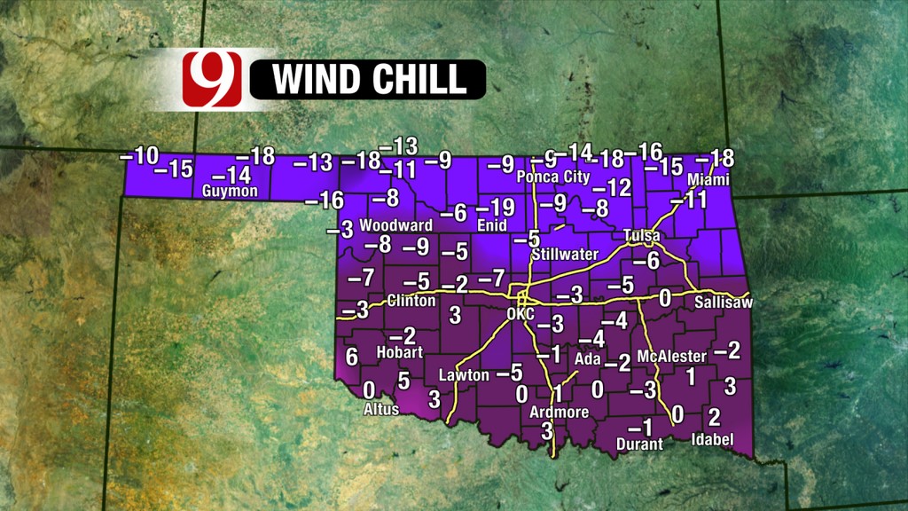 Windchills are below zero across a substantial section of Oklahoma on this Monday morning- the graphic above from News9 provides a good overview. Nationally, reports have come in from North Dakota of some windchills in that state as low as sixty degrees below zero, with most readings early this morning from thirty to fifty degrees below zero wind chills for much of the Dakotas, Minnesota, Iowa and Northern Illinois.
Alan Crone with the News on 6 writes in his Monday morning weather blog that "The weekend snow and cold air will continue to keep the air mass frigid both today and tomorrow before the shallow arctic air slides eastward and modifies quickly. But the short term will feature a strong arctic surface ridge of high pressure building across northern OK this morning. This will keep the sky mostly clear and the temps very cold. Surface temps will be in the lower single digits but wind chill values could easily range from -10 to -20 across part of northern Ok and southeastern Kansas. We do have a large area included in wind chill advisories this morning and a few counties northeast of Tulsa included in wind chill warnings."
For Oklahoma, the big chill will be relatively short lived. Crone says for Green Country that "The surface ridge of pressure will quickly move eastward after Tuesday morning with southwest winds increasing during the afternoon. Tuesday morning lows in the single digits to near 10 will move into the upper 30s or lower 40s with increasing clouds Tuesday afternoon. Moisture is expected to return across eastern OK Tuesday night into Wednesday morning with some light drizzle possible during the pre-dawn Wednesday period."
Click here to read all of Alan's blog about current weather conditions here in Oklahoma.
WebReadyTM Powered by WireReady® NSI
Top Agricultural News
More Headlines...


