


Agricultural News
Northwest Oklahoma In the Bulls Eye For Next Snow Event on Tuesday- The Latest Graphics
Mon, 03 Feb 2014 05:11:30 CST
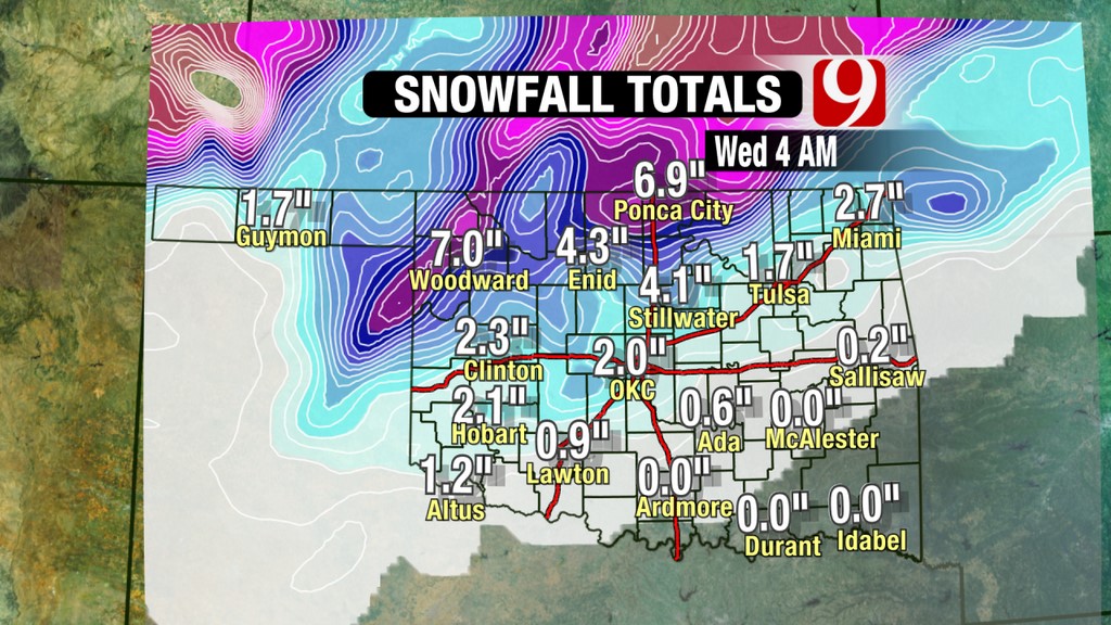
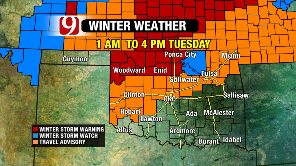 Winter will continue to camp out on top of Oklahoma all of this week. It appears that two more storm systems are ready to make a run across the state starting early Tuesday morning. The graphic above, courtesy of Jed Castles at News9 in Oklahoma City, shows the storm watches and warnings for Tuesday- heaviest snow will likely be in northwest Oklahoma. That is seen by the map below with Woodward looking to be right in the middle of the heaviest snow that is expected from this next system.
Northwest Oklahoma was missed by the storm that rolled in early Sunday morning, with southwestern Oklahoma getting some of the better snowfall totals from that storm- for example- seven inches of snow were reported in the Duncan area.
Alan Crone with the News on 6 weather staff writes in his Monday morning blog of a total of three storm systems that are headed this way- starting with the one these graphics we have are referring to- note that Alan is looking at Tulsa as the center of the universe and says "The next system will arrive late Tuesday morning across the southern plains and the state of Oklahoma. This is a strong storm system but the track of the storm in most model data would now lead to higher snowfall totals across the north central and northwestern OK region. Significant snow is likely to occur in portions of central and east central Kansas. We should see some light precipitation beginning pre-dawn Tuesday morning across eastern OK in the form of light freezing drizzle or light sleet. Some snow would be possible by midday, but mainly near and northwest of the I-44 corridor. This system may also be a fast moving storm. A dry slot will quickly form and could greatly limit the precipitation across southwestern and south-central OK Tuesday morning and spread into northeastern OK after the noon hour. The areas to the northwest of Tulsa may be included in a winter storm warning, but most of our area wills more than likely remain in a winter weather advisory for this Tuesday event.
"Wednesday will feature very cold air with temps in the single digits to lower teens for lows and highs in the upper teens and lower 20s. We'll get a break Wednesday with no precipitation in the forecast.
"The second wave will approach the state late Thursday morning or possibly early Friday morning. This wave will have plenty of cold air in place before the precipitation begins which means all snow across eastern OK. But the accumulation will remain light.
"The third disturbance for this 7 day planner will arrive Friday night late into Saturday morning to midday across central and eastern OK. This disturbance will also have cold air in place meaning most if not all precipitation types would remain snow for northern OK and southern Kansas. This system may also have the potential for accumulating snow."
WebReadyTM Powered by WireReady® NSI
Top Agricultural News
More Headlines...


