


Agricultural News
Mid Week Winter Weather Prospects- The Latest Graphic Shows Rain and Snow
Tue, 04 Mar 2014 06:17:10 CST
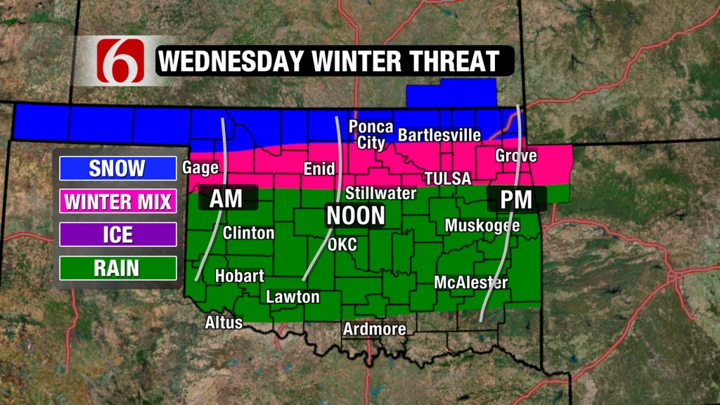 Winter weather is not willing to leave the state as of yet- and it appears that a little more precipitation may be in the mix mid week. The graphic above from Travis Meyer at the News on 6 in Tulsa shows moisture of one sort or another rolling through.
According to Alan Crone in his Tuesday morning weather blog as found on the News on 6 website- "We're tracking another system Wednesday that could provide some wintry precipitation across potions of the state. Temps today will move into the mid or upper 30s with partly sunny conditions.
"The snow cover combined with the arctic air will keep temps in the single digits to lower teens for the next few hours. The daytime highs will move into the mid and upper 30s this afternoon with increasing high clouds and southeast winds around 10 mph. Wind chill values will not drop into the -5 to -15 ranges this morning and no wind chill advisory will be posted for the area this morning. Our next upper level system will arrive Wednesday with a chance of light rain-snow mix, but the timing of the system will need to be monitored carefully.
"The current model data suite and observational data suggest the Wednesday system will arrive by afternoon into the evening hours with temps moving into the upper 30s near 40 by afternoon. The temps Wednesday morning will start in the lower 20s. If the system arrives earlier than anticipated, Wednesday morning could support a chance of light freezing rain. If the system arrives as scheduled, we'll see light showers Wednesday late afternoon before transitioning to snow. As the system exits the area Wednesday night snow will be possible. The GFS has trended "wetter" with this system and is now offering anywhere from 1 to near 2 inches of snow across portions of the state. The NAM is the "outlier" and keeps us very dry. The EURO is similar to the GFS and moves the shortwave across the northwestern third of the state into the southeastern third by the late Wednesday night time period."
CLick here for Alan's complete blog posting for Tuesday, March 4th.
WebReadyTM Powered by WireReady® NSI
Top Agricultural News
More Headlines...


