


Agricultural News
Rainfall Totals Top Two Inches in Stephens County- the Map from Sunday-Monday
Tue, 22 Apr 2014 05:58:04 CDT
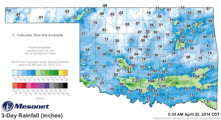 Rainfall totals for the Easter Sunday (and Monday after Easter) system piled up mostly in the southern half of the state, with the heaviest totals from Stephens County east to almost the state line. In fact, the biggest total seen at the Mesonet stations across the state was at the Ketchum Ranch in Stephens County at 2.23 inches.
Check the map above to see these rainfall tallies.
On Monday morning, we did hear about heavier rainfall totals in southwest Jackson County- south of the Hollis and Altus Mesonet stations that both had slightly more than a half inch of rain in their gauges.
A listener and email reader of ours reported that he had an inch of rain at his place in southwest Jackson County and that neighbors had as much as two and half inches of rainfall.
According to Alan Crone with the News on 6, our next rain making system arrives Wednesday afternoon. He writes in his Tuesday morning blog "As the wave approaches, strong south winds will return Wednesday with highs in the lower 80s. Gulf Moisture will attempt a quick return into the state ahead of this system. A surface low is expected to develop across ether NW OK or SW Kansas with a dry line establishing southward across far western OK by Wednesday afternoon. The dry line separates warm-moist air to the east from dry air to the west. As strong winds aloft move over NW OK Wednesday afternoon and evening, the dry line will begin moving eastward and scattered storms are expected to form near and ahead of this feature. A few of these storms will be severe. As the evening hours approach, the main upper level wave will begin sliding quickly east or northeast but a strong low level jet is expected to keep storms going into the pre-dawn Thursday morning period across part of southeastern Kansas and northeastern OK."
Click here for Alan's full review of the weather from his perch in downtown Tulsa.
WebReadyTM Powered by WireReady® NSI
Top Agricultural News
More Headlines...


