


Agricultural News
Best Rains of 2015 Received- With More Coming in Next Seven Days- The Latest Maps
Tue, 14 Apr 2015 05:40:24 CDT
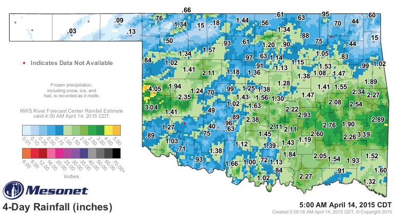 Rainfall totals since the beginning of this past weekend are the best seen on a wide spread basis across Oklahoma in 2015, with more rain being predicted in the next seven days. The graphic above is from the Oklahoma Mesonet and shows rainfall totals since this past Friday morning, April 10th- and shows more than 20 Mesonet stations with two inches of rain or more in that time period.
Topping the rainfall parade was Cheyenne in Roger Mills County with over four inches of rainfall for the period. Two Mesonet sites exceeded the three inch rainfall mark- Erick- the closest Mesonet site to Cheyenne with 3.04 inches and Talihina all the way across the state to almost the Arkansas state line where they recorded 3.39 inches of rainfall.
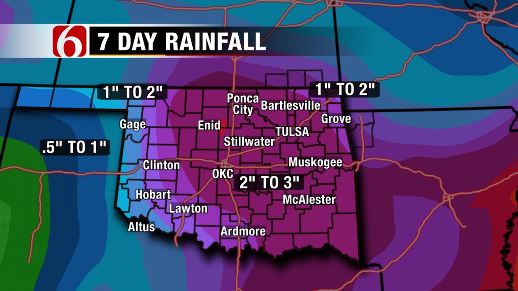
Rainfall largely missed the Oklahoma Panhandle- although the seven day forecast suggests even the three Panhandle counties could see an inch or so of moisture. Heaviest totals- as shown in the News on 6 graphic below- may be in a large area of the state stretching from Idabel to Alva and from Grove to southwest of Oklahoma City.
According to the Tuesday morning weather blog written by Alan Crone of the News on 6- a rain making system will slide eastward the latter part of this week and rain chances will move from west to east as it comes- "The upper air flow will quickly bring a developing upper level low across the Pacific Northwest and into the four corners region during the next 36 hours. This low is expected to become "cut-off" from the main upper level flow and will remain to our west for several days. A few showers or storms will be possible Wednesday and Thursday with the low to the west, but the higher chances will arrive Friday into Saturday as the low finally gets a shove eastward.
"Model output suggests a few things should happen as the low begins moving eastward. A surface front should move across the state sometime Thursday into Friday with north wind an increase in thunderstorm activity Thursday night into Friday. The threat for severe weather appears low, and mainly to the south or west.
"Friday the main upper level low begins moving eastward. A surface area of low pressure is expected to rapidly develop somewhere across the southern plains. Late Friday night as the upper level low lifts out over central and eastern OK, the surface low should also lift northeast into the state. This will bring rain and storms back to the region Friday night into Saturday."
As for an actual forecast- click here for the News9 in Oklahoma City predictions which show chances of rain today- nothing on Wednesday- but then rain chances pick up for Thursday all the way through next Monday- this for central and western Oklahoma.
WebReadyTM Powered by WireReady® NSI
Top Agricultural News
More Headlines...


