

Agricultural News
Drought Monitor Report Shows 95% of Oklahoma Abnormally Dry or Worse
Thu, 16 Dec 2021 14:26:08 CST
 According to the latest U.S. Drought Monitor report, the past week was marked by a much more active storm pattern across the West Coast and Northern Rockies with areas of heavy rain along the coast and valley locations. Further inland, the higher elevations of the Cascade Range, Klamath Mountains, Sierra Nevada Range, northern Great Basin, and the Northern Rockies have all received significant snowfall accumulations this week. The storm event, fueled by an atmospheric river, provided a much-needed boost to snow water equivalent (SWE) levels in the Far West.
In the Lower Mississippi, Tennessee, and Ohio Valley, an outbreak of violent thunderstorms including dozens of tornadoes, erupted along a path spanning from northeastern Arkansas to northeastern Kentucky. The tornados moved very rapidly through the region on Friday night with devastating effects, especially in the southeastern town of Mayfield, Kentucky.
If you are inclined to help folks who were affected by those storms, here are couple of resources:
OKFB Foundation accepting donations for Kentucky producers affected by tornadoes
Kentucky agriculture offers a conduit for relief help for farmers harmed by tornadoes
In the Southern Plains conditions continued to degrade across areas of Texas and Oklahoma where unseasonably warm and dry conditions prevailed. The dry conditions showed up on a variety of drought indicators including satellite-based soil moisture and evaporative demand tools.
In the High Plains eastern Wyoming, eastern Montana, central North Dakota, southern South Dakota, and northwestern Nebraska saw improvements based on short-term precipitation (30 to 90-day period). This included beneficial snowfall in southern portions of South Dakota where observed totals ranged from 6 to 18 inches with the highest totals in southwestern South Dakota. In these areas, soils have yet to freeze throughout the soil column and melting snows are infiltrating and helping to improve soil moisture levels. According to NOAA NOHRSC, snow coverage in the Upper Midwest Region (includes portions of Wisconsin, Minnesota, the Dakotas, eastern Montana, and northwestern Wyoming) is currently at 52.5% with an average depth of 1.5 inches and a maximum depth of 28.8 inches. Despite some improvements on the map, it is noteworthy that average temperatures across the High Plains region have been well above normal since September.
In the West, rainfall accumulations along the coastal areas from Washington to California ranged from 3 to 13+ inches with the highest accumulations observed in the coastal ranges of northwestern Oregon and along the Central Coast of California. In terms of snowfall during the multi-day storm event, total accumulations exceeded 6 feet in areas of the Central Sierra while areas in the southern Cascades received up to 3 feet, according to data ranging from Dec. 8 to Dec. 14, 2021. Despite the beneficial nature of this week's storm event, significant precipitation deficits (ranging from 4 to 20+ inches) still exist across California and the state's largest reservoirs are still at critically low levels.
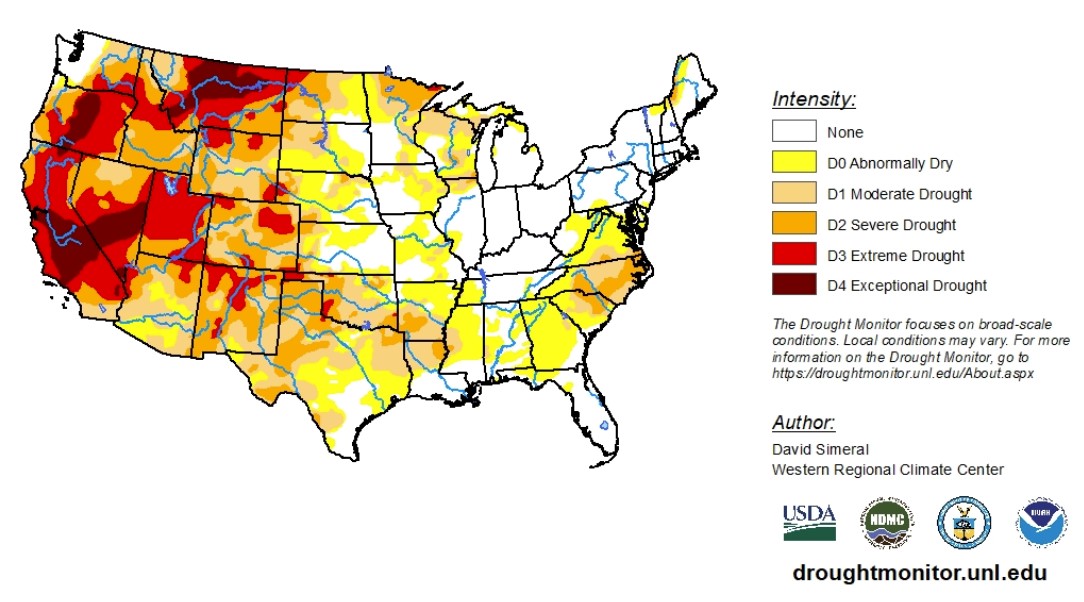
To view the Contiguous U.S. Drought Map, click here.
Looking ahead, moderate-to-heavy precipitation accumulations are expected for most of the western half of the country. In the eastern third, near-normal precipitation is expected.
From Dec. 13 to Dec. 17, 2021, the West and the Dakotas are expected to receive higher-than-normal levels of precipitation. Lower-than-normal levels of precipitation are expected for the South, radiation north to Nebraska and out to the East Coast. At the same time, most of the southern half of the country is practically guaranteed higher-than-normal temperatures. The West Coast and the northern third of the country is expected to experience lower temperatures.
To view the 6 - 10 Day Precipitation Outlook, click here.
To view the 6 - 10 Day Temperature Outlook, click here.
According to the Monthly Drought Outlook map, most of the country will continue to see drought conditions persist or get worse except for the Pacific Northwest, down into western Wyoming.
To view the Monthly Drought Outlook map, click here.
Oklahoma
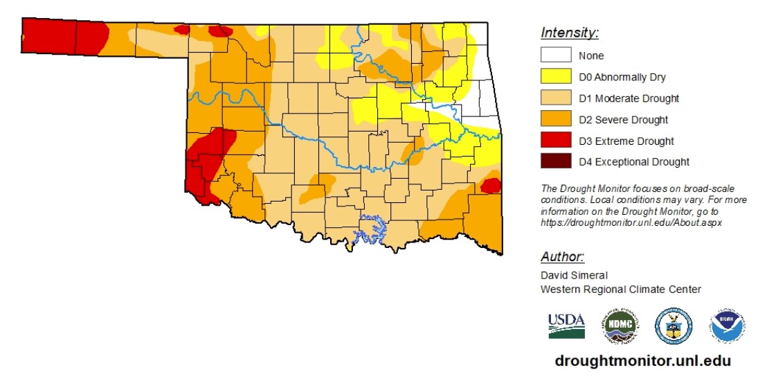
According to data from Dec. 8 to Dec. 14, 2021, drought conditions in Oklahoma continue to deteriorate. As of Dec. 14, 95% of the state is experiencing abnormally dry conditions or worse. Moderate drought conditions or worse account for nearly 83%. Severe drought conditions or worse account for 36%. Extreme drought conditions doubled, now accounting for 8%.
Fires have begun to erupt amid these dangerous conditions.
All of Harmon County and nearly all of Cimarron County are classified as in extreme drought. Extreme drought conditions are also reported in Beaver, Beckham, Custer, Greer, Harmon, Harper, Jackson, Kiowa, LeFlore, Texas, Washita and Woods counties.
The 6-to-10-day precipitation outlook map shows Oklahoma is likely to receive lower-than-normal precipitation levels. The 6-to-10-day temperature outlook map shows higher-than-normal temperatures are very likely.
To view the Oklahoma drought map, click here.
WebReadyTM Powered by WireReady® NSI
Top Agricultural News
More Headlines...


