

Agricultural News
Not Much change in Oklahoma Drought Conditions as Summer Conditions Set In
Thu, 23 Jun 2022 10:03:18 CDT
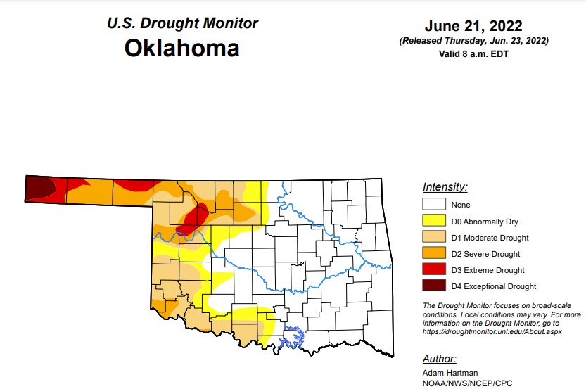 According to the latest drought monitor, in Oklahoma, exceptional drought is the same as last week at 1.4 percent, with Cimarron County being the only county in the state facing levels of exceptional drought.
Extreme drought or worse is also the same as last week at 5.4 percent.
Severe drought or worse is at 15.8 percent, which is the same as last week.
Moderate drought or worse has actually increased from last week's 30.3 percent and is now at 31.2 percent.
Abnormally dry or worse conditions have also increased slightly at 41 percent (last week was 40.3 percent).
The 6-10 day precipitation outlook map shows an above 33 percent chance of rain for the Oklahoma Panhandle and a near-normal percent chance of precipitation for the rest of the state. Some high temperatures can be expected this weekend, but that will be followed by a cold front the following week which may yield some moisture for the drier parts of the state.
To view the Oklahoma Drought Map, click here.
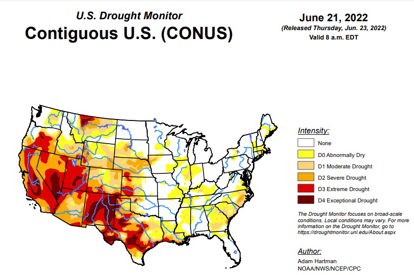
According to the U.S. Drought Monitor Report, above-normal temperatures plagued much of the central and eastern contiguous U.S. (CONUS) this week from the Great Plains eastward to the Mississippi Valley and Southeast. The western third of CONUS, the Northeast, and coastal Mid-Atlantic experienced seasonal to below-normal temperatures. Precipitation was lacking in many locations that experienced excessive (in some cases record) heat, leading to widespread expansion of abnormal dryness and moderate drought conditions along the Mississippi and Ohio Valleys, the Southern Plains, and the Southeast. From the Central Plains northward, despite the excessive heat (daytime high temperatures above 100°F several days this week), recent improvements driven by an active storm track leading up to this week resulted in modest, more targeted degradations in the drought depiction. Another week of heavy rainfall warranted improvements in Montana. In the Pacific Northwest, below-normal temperatures and recent improvements from an active weather pattern leading up to this week resulted in improvements in some of the long-term drought indicators. Heavy rainfall associated with the Southwest Monsoon also fell across parts of the Four Corners region. However, this only acted to halt any further degradations this week. Given drought is strongly entrenched in the Four Corners, an active Southwest Monsoon circulation will need to persist for conditions to improve.
In the Southern Plains, extreme heat, high winds, and below-normal precipitation continued in Texas, leading to another round of degradations this week across the state. Extreme heat and below-normal precipitation also lead to the widespread expansion and addition of abnormal dryness (D0) and moderate drought (D1) across the Lower Mississippi and Tennessee Valleys. Soil moisture conditions quickly deteriorated this week (falling below the 30th percentile across many areas that saw expansion). Additionally, daily and 7-day average USGS stream flows fell below-normal (below the 24th percentile) and vegetation indices are also indicating increased stress to plants. Short-term (30 to 60-day) deficits are starting to accumulate also, with many areas across the Lower Mississippi and Tennessee Valleys experiencing 4 to 6 inch rainfall deficits over the last 60 days.
In the High Plains, much of the Region has seen beneficial rainfall and temperatures averaging near to below-normal over the past 30 days, with the exception of a few locations. Some targeted improvements were warranted across parts of southeastern Nebraska this week, which picked up 1.5 to 3 inches of rainfall (per AHPS estimates). Targeted improvements were also made in parts of Colorado and northern Wyoming due to a robust Southwest Monsoon circulation and an active storm track across the Northern Tier, respectively. Conversely, high winds and hot temperatures, which exceeded 100°F several days this week, resulted in high evapotranspiration rates and, subsequently, degradations for parts of the Central Plains. Evapotranspiration rates approaching 0.5 inches per day were reported in western Nebraska.
In the West, much of the Northern Tier of the U.S. from the Pacific Northwest to the Northern Plains has seen marked improvements in recent months due to a persistent storm track and near to below-normal temperatures. That same pattern continued this week, leading to 1-category improvements from the Pacific Northwest eastward to Montana. Improvements in Montana are the result of 7-day precipitation surpluses of more than 1 inch for many locations and near to below-normal temperatures. In the Pacific Northwest, long-term indicators continued to improve due to the recent storminess and below-normal temperatures leading up to this week. In the Four Corners region, heavy rainfall was observed in a large swath stretching across western New Mexico, due to a robust Southwest Monsoon circulation. However, there were no marked improvements to drought indicators this week to warrant improvements. Given drought is strongly entrenched in the Four Corners, an active Southwest Monsoon circulation will need to persist for conditions to improve.
To view the Contiguous U.S. Drought Map, click here.
Looking ahead, a storm system near the coast of the Carolinas will bring chances for heavy rainfall to parts of the Eastern Seaboard over the next couple of days (June 23-24). Meanwhile, another storm system will intensify and move eastward from the Northern Plains to the Great Lakes. The trailing frontal boundary associated with this system will bring increased chances of rainfall to much of the eastern U.S. However, rainfall is likely to be hit-or-miss and remain below-normal for many locations, especially along the Lower and Middle Mississippi Valley. The passage of the frontal boundary in the eastern U.S. should bring more seasonal daytime temperatures by the start of the work week (Monday, June 27). An active Southwest Monsoon circulation is forecast to bring increased precipitation and below-normal maximum temperatures to parts of the Four Corners region, with below-normal maximum temperatures extending into the Central Plains.
The Climate Prediction Center's 6-10 day outlook (valid June 28 to July 2, 2022) favors above-normal temperatures across much of California, the Great Basin, and Eastern Rockies. Above-normal temperature probabilities also extend from the Central and Southern Plains eastward to the Appalachians and southward to the Gulf Coast. Near to below-normal temperatures are favored across the Northern Tier of the contiguous U.S. (CONUS), as mean mid-level high pressure is expected to remain farther to the south. Below-normal temperatures and above-normal precipitation are favored for much of the Four Corners region, associated with a robust Southwest Monsoon circulation. Near to above-normal precipitation probabilities also extend along the Northern Tier from the Pacific Northwest to the Great Lakes, associated with storm activity. Increased chances of below-normal precipitation across the northern Great Basin and from the Middle Mississippi Valley to the Northeast are associated with dry northerly mean surface flow and surface high pressure, respectively.
To view the 6 - 10 Day Precipitation Outlook map, click here.
To view the 6 - 10 Day Temperature Outlook map, click here.
To view the Monthly Drought Outlook map, click here.
WebReadyTM Powered by WireReady® NSI
Top Agricultural News
More Headlines...


