


Agricultural News
Extreme Drought Expands in Parts of Western Oklahoma- Here's the Map
Thu, 19 May 2011 11:22:34 CDT
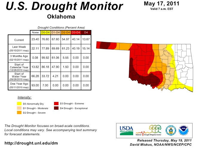 Drought conditions have expanded in portions of western Oklahoma, based on the latest Drought Monitor released on Thursday morning, May 19, 2011.
According to Gary McManus, Associate State Climatologist for the Oklahoma Climatological Survey, we went from D2 to D1 along the eastern edge of the I35 corridor and also have a notch of D2 extending down into the southwest, all courtesy of last week's weird rainfall patterns. Unfortunately, extreme (D3) drought has expanded in western Oklahoma up through the Kansas state line. The map above is of the latest classification released this week
The areas that are in the Extreme Drought classification have had far less precipitation than normal over the last 90 to 180 days, an obvious reason for the D3 classification.
Here is the full commentary for all of the southcentral plains- which includes Oklahoma, Texas and Kansas.
Central and Southern Plains: Persistent rains that had brought relief to parts of north-central and northeastern Texas since early April finally became more widespread and heavier, soaking parts of central and eastern Texas, near Del Rio, TX, and portions of the TX Panhandle with 1.5 to 4 inches. Unfortunately, little or no rain fell on southwestern, extreme western, west-central, and extreme southern Texas, and along the western Gulf Coast. Accordingly, where the heaviest rains occurred, a 1-category improvement was made, while continued dryness in the west & southwest maintained or expanded D3 and D4. In north-central Texas where 2 to 4 inches of rain fell, conditions improved to D1 from Runnels and Coleman counties northeastward to Tarrant county, and to D0 from Tarrant and Dallas counties to the Oklahoma border (Grayson to Bowie counties). D2-D4 were also improved by one category in surrounding areas where the rainfall was greatest. Similarly, in south-central Texas, 1.5 to 4 inches of rain eased D4 conditions near Del Rio (Val Verde county), in La Salle, Dimmit, and Webb counties, and Bell, Burnet, & Llano counties. In eastern Texas, D4 was eased from Houston, northern Trinity, Angelina, southern Nacogdoches, and southern Cherokee counties. Although this week's rains fell on the watershed for Sam Rayburn Reservoir, the lake continued to drop, reaching 1.99 million acre-feet (normally at 2.9 million acre-feet), and much of what remained was inaccessible. In the extreme northern Panhandle, 1 to 2 inches of rain diminished the D3 in Hansford & Sherman counties. Farther north, moderate to heavy rains (1 to 3 inches) fell on central and northeast Colorado, most of Nebraska, and parts of eastern Kansas and central and eastern Oklahoma. A 1-category improvement was made where the largest totals occurred. In addition, the eastern edge of the drought (D0-D2) in the central Great Plains was trimmed as decent rains fell there. In Nebraska, releases on the Platte River from Lake McConaughy increased on May 17. Flows doubled to 4000 cfs, with 7000 cfs entering the lake. Low land flooding will increase in intensity with North Platte River stage expected to reach the 1971 record. A more dire situation is possible as 2 million acre feet of water is estimated in the central Rockies snow pack, but only a million acre feet of storage is available in McConaughy now. Any additional heavy rains in this region will aggravate conditions.
In contrast, exceptional short-term dryness continued in western sections of the state, expanding D4 into the Big Bend region and D3 into the northern Texas Panhandle. Elsewhere, another dry week in northeastern New Mexico pushed D3 northward and into southeastern Colorado. According to AHPS precipitation, this region has observed less than 10 percent of normal precipitation the past 90-days, and less than 25 percent the past 6 months. Similar conditions existed in western Oklahoma northward into south-central Kansas, and D3 was added here. According to the USDA/NASS, May 15 state winter wheat conditions rated very poor or poor included: CO 41 percent; KS 55 percent; OK 80 percent, and TX 75 percent. Similarly, May 15 pasture and range conditions considered very poor or poor included: AZ 55 percent; CO 41 percent; KS 35 percent; NM 80 percent; OK 50 percent, and TX 71percent.
WebReadyTM Powered by WireReady® NSI
Top Agricultural News
More Headlines...


