


Agricultural News
Wind Chills Dip Below Zero in Northern Oklahoma- The Latest Graphic
Thu, 02 Jan 2014 06:29:31 CST
 Janaury first saw 2014 start with an arctic front moving across Oklahoma bringing more cold air back to the state along with some light snow along the OK-Kansas state line area. This fast moving short wave that produced the light snow is well east of the state this morning, but the frigid air will remain during the short term. We'll be riding the roller coaster of temps once again but the ride up will not be as robust as last week.
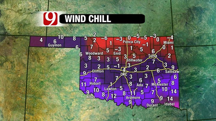
Wind chills are brutal this morning as you can see in the graphic above, courtesy of Lacey Swope of News9.
The afternoon highs are expected to remain near or below freezing with some sunshine and north winds. Temperatures will improve on Friday and Saturday with afternoon highs moving into the 40s or lower 50s but another strong cold front will roll across the state late Saturday night bringing more shallow arctic air to the region. The front will pass the area Saturday night and a short wave will trail across the central plains producing some light wintry precip, mainly to our north and east. But model data indicates some rain will be possible Saturday afternoon or evening across far eastern OK for a short time period. As the cold air arrives, we may see small window of opportunity for a transition from rain to freezing rain and then to some light sleet. The overall coverage will be very low, but this may require a slight increase in probability for the north and eastern sections of the state. Our chance will remain anywhere from 20 to 30% with the subfreezing air remaining from Sunday through at least Tuesday or even Wednesday of next week. This would include both overnight lows and daytime highs.
Read more on the weather outlook for today into early next week from the daily weather blog written by Meterologist Alan Crone from the News on 6 in Tulsa. Click here for that.
WebReadyTM Powered by WireReady® NSI
Top Agricultural News
More Headlines...


