


Agricultural News
Drought Improves Across Parts of The State But Persits in Western Oklahoma
Thu, 05 May 2022 11:47:25 CDT
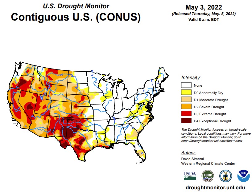
 According to the latest U.S. Drought Monitor Report, this week was marked by ongoing active weather across areas of the conterminous U.S. including the Pacific Northwest, Northern Rockies, Plains, Lower Midwest, and isolated areas of the South and Southeast. The most severe weather was observed across the Central Plains and areas of the Midwest where numerous tornadoes touched down in areas including eastern Kansas, southeastern Nebraska, and northern Illinois. Widespread heavy rainfall accumulations were also observed, ranging from 2 to 7 inches, with the heaviest accumulations in eastern Nebraska. The rainfall events provided much-needed moisture to the region-boosting soil moisture levels across parched areas from Kansas to South Dakota. In the West, fast-moving storm systems delivered late season high-elevation snowfall to the Cascades of northern Oregon and Washington, the Northern and Central Rockies, and areas of the northern Great Basin. The highest snowfall totals (8 to 12+ inches) were observed in the Salmon River Mountains of Idaho, the Ruby Mountains of northeastern Nevada, and the Wind River Range of Wyoming. In California and the Southwest, conditions were dry during the past week with strong winds observed across the region. The windy, dry conditions exacerbated fire-weather conditions in Arizona and New Mexico where several large early-season wildfires are currently impacting the region. In northern New Mexico, the Hermits Peak Fire, situated east of Santa Fe in the Sangre de Cristo Mountains, has burned 147,909 acres and is only 20% contained (May 4), according to the National Interagency Coordination Center. On the water-resource front, the Colorado River Basin water situation continues to deteriorate due to the long-term impacts of drought with water levels at Lake Powell and Lake Mead currently at 24% full and 31% full, respectively. With Lake Powell's water surface elevation currently at 3,522 feet, it is quickly approaching the 3,490-foot threshold level at which Glen Canyon Dam can continue to generate hydropower. The U.S. Bureau of Reclamation (USBR) announced (May 3) two urgent drought response actions to help bolster water levels at Lake Powell. The plan includes additional upstream releases from the Flaming Gorge Reservoir (~500,000 acre-feet of water) as well as reducing Glen Canyon Dam's annual release volume from 7.48-million acre-feet to 7 million acre-feet. In terms of this week's map, short-term precipitation led to targeted improvements in the Pacific Northwest, Central Plains, South, and the Southeast, while degradations were registered in the Southwest, Texas, Southeast, and the Mid-Atlantic.
In the Southern Plains, conditions on the map were a mixed bag of improvements and degradations. In southern Louisiana, isolated areas of light-to-moderate rainfall (2 to 4 inches) improved areas of Moderate Drought (D1), Severe Drought (D2), and Extreme Drought (D3) as well as eliminated pockets of Moderate Drought (D1) in northern Louisiana and southern Arkansas. In areas of Texas (Panhandle, north-central, west-central, Trans-Pecos), isolated bands of heavy rainfall (2 to 4 inches) helped to improve drought-affected areas. Conversely, the combination of above-normal temperatures, dry soils, and increased evaporative demand led to degradation in areas of the Panhandle, southeastern Texas, and the Trans-Pecos. In the Panhandle of Oklahoma, small areas of Exceptional Drought (D4) expanded in response to short-term rainfall deficits. Reports in this area include very poor rangeland conditions and local ranchers having to rely on supplemental feed for cattle. According to the latest USDA Oklahoma Crop Progress and Conditions report (May 2), wheat crop conditions were rated 51% poor to very poor and soil moisture was 63% short to very short. For the week, average temperatures were mostly above normal (2 to 8+ deg F) with the greatest positive anomalies observed across Texas and western Oklahoma.
In the High Plains, on this week's map, widespread improvements were made in South Dakota, Nebraska, and Kansas in response to significant rainfall accumulations that helped to improve soil moisture levels and boosted streamflow levels. Rainfall totals for the week ranged from 2 to 8+ inches with the highest totals observed in central South Dakota, eastern and central Nebraska, and northern Kansas. However, some drought-stricken areas of the region, including extreme southeastern South Dakota, northeastern Nebraska, and central Kansas, largely missed out on this week's storms. In the eastern plains of Montana, improving conditions (precipitation, soil moisture) led to reduction in areas of Severe Drought (D2) and Extreme Drought (D3). However, it should be noted that recent improvements in eastern Montana are not uniform and many areas are still coping with the impacts (agricultural) of the longer-term drought situation. Average temperatures were below normal across the northern half of the region, with negative departures ranging from 2 to 10+ deg F below normal and the greatest departures observed in eastern portions of the Dakotas. In the southern half of the region, average temperatures were 2 to 8 deg F above normal.
In the West, several storm systems moved through the norther tier of the region bringing light to moderate snowfall accumulations to the higher elevations of the Cascades, northern Great Basin, and the Central and Northern Rockies as well as light rainfall to coastal areas and low-lying inland valleys of Idaho, Oregon, and Washington. Improvements were made in areas of Moderate Drought (D1), Severe Drought (D2), Extreme Drought (D3), and Exceptional Drought (D4) in Oregon in response to a combination of factors including normal to above-normal SWE, recent storm events, and improved soil moisture levels and streamflows. Likewise, improving conditions in northern Wyoming led to removal of areas of Extreme Drought (D3) in the Big Horn Mountains where current SWE is 108% of median. Elsewhere, conditions deteriorated on the map in northwestern Arizona and across much of New Mexico. Looking at snowpack data across the West at a regional scale (2-digit HUC), the NRCS SNOTEL network (May 3) reported the following median SWE levels: Pacific Northwest 111%, Missouri 99%, Souris-Red-Rainy 116%, California 60%, Great Basin 62%, Upper Colorado 76%, Arkansas-White-Red 50%, Lower Colorado 36%, and Rio Grande 33%. According to NRCS National Water and Climate Center's reservoir summary report (April 1), statewide reservoir storage levels were below normal in all western states with exception of Washington state. In California, the state's two largest reservoirs are at critically low levels moving into the dry season with Shasta Lake currently at 40% of total capacity on May 3 and Lake Oroville at 55% of capacity. In Southern California, the Metropolitan Water District of Southern California announced (April 27) that one-third of its users will be subject to restrictions that limit outdoor watering to one day per week as a measure to reduce water usage. In the Colorado River Basin, Lake Powell was at 24% of capacity and Lake Mead 31% of capacity on May 3, according to the USBR. In the Rio Grande Basin, New Mexico's Elephant Butte Reservoir was 13% full.
To view the Contiguous U.S. Drought Map, Click Here.
Looking ahead, the NWS WPC 7-Day Quantitative Precipitation Forecast (QPF) calls for moderate-to-heavy liquid (liquid = rain + SWE) precipitation accumulations ranging from 2 to 5+ inches across eastern portions of the Central and Southern Plains and the Lower Mississippi Valley. In the Lower Midwest and the Mid-Atlantic, precipitation totals are expected to range from 1 to 3 inches. Out West, accumulations ranging from 1 to 5 inches are forecasted for the coastal ranges and the Cascades of western Oregon and Washington. Further inland, lighter accumulations (< 2 inches) are expected in the Northern Rockies of Idaho, Montana, and Wyoming. Further south, conditions are expected to be dry across California, the Great Basin, and the Desert Southwest. The CPC 6-10-day Outlooks calls for a moderate-to-high probability of above-normal temperatures across the eastern two-thirds of the conterminous U.S. with exception of some coastal areas of the Mid-Atlantic and Florida. Below-normal temperatures are expected across much of the West with exception of eastern portions of Colorado and New Mexico where there is a low-to-moderate probability of above-normal temperatures. In terms of precipitation, the wetter-than-normal pattern is expected to persist across the northern tier of the West as well as in areas of the Great Plains. In coastal areas of the Far West, near-normal precipitation is expected. Across much of the eastern half of the conterminous U.S., including areas of the Southern Plains, Lower Midwest, Mid-Atlantic, and the Northeast, there is a moderate-to-high probability of below-normal precipitation.
To view the 6 - 10 Day Precipitation Outlook, click here.
To view the 6 - 10 Day Temperature Outlook, click here.
To view the Monthly Drought Outlook map, click here.
Oklahoma:
The precipitation in Oklahoma earlier in the week had some impact on the report, but the Wednesday and Thursday rains will not be reflected in the report until next week.
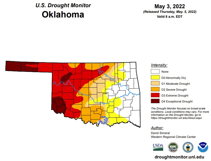
In Oklahoma, 2,462,066 people are affected by exceptional drought. Exceptional Drought is at 11% with Cimarron, Texas, Beaver, Major, Woodward, Dewey, Roger Mills, Beckham, Harmon, Jackson, Greer, Kiowa and Tillman Counties in Exceptional drought (last week, this number was at 9.4% and last month is was at 8.3%) 39.4% of the state is in an extreme drought this week, which is up from last week at 36%. 55.3% of the state is in severe drought (last week was 57.6) . 65.4% of the state is in moderate drought or worse, down from last week at 72.7%. Also down from last week is part of the state that are abnormally dry or worse at 77.3% (last week was at 80.8% and last month was 86.2%). We currently have 66 counties with USDA disaster designations, and this is the 56th driest year to date over the past 128 years. This Sunday, May 8th, we will reach record high values with the high for all over the state ranging from the high 90s to over 100 degrees in the lower southwest corner. Between the two storm systems, parts of east-central OK have received 8-12 inches of rainfall, with Haskell leading the way at 11.4 inches. The panhandle and parts of western Oklahoma on the other hand received less than an inch of rain.
The 6-10 day precipitation outlook map shows western Oklahoma and the panhandle has a 33-50% chance of rain or more and the eastern side has a lower probability of showers. Warmer temperatures can be expected as we enter next week.
To view the Oklahoma drought map, Click Here.
WebReadyTM Powered by WireReady® NSI
Top Agricultural News
More Headlines...


